
Product details
Leica BLK2GO Handheld Imaging Laser Scanner
Mobile Reality Capture for Fast and Flexible 3D Documentation
Introduction to Leica BLK2GO
The Leica BLK2GO Handheld Imaging Laser Scanner is a portable reality capture solution designed to simplify 3D data collection. By combining LiDAR scanning with imaging technology, the device allows users to capture accurate spatial data while moving freely through indoor and outdoor environments.
What Is the Leica BLK2GO
Leica BLK2GO is a handheld laser scanner that enables mobile mapping without tripods or complex setups. It captures point cloud data in real time, making it suitable for rapid documentation of existing conditions and spatial layouts.
Handheld LiDAR Technology
The scanner integrates advanced LiDAR sensors that continuously capture 3D geometry as the operator walks through a space.
Integrated Imaging System
Built-in cameras provide contextual imagery that enhances the usability and interpretation of collected point cloud data.
Key Features of Leica BLK2GO
Real-Time 3D Data Capture
The system records spatial data continuously, reducing the need for static scanning positions.
Portable and Lightweight Design
Its compact form factor supports one-handed operation, improving mobility and ease of use in the field.
Autonomous Data Processing
Onboard processing helps manage data capture and alignment during scanning.
Applications and Use Cases
Building Documentation
Ideal for capturing existing conditions of buildings for renovation, facility management, or digital archiving.
Construction and Engineering
Supports fast site documentation and progress tracking in construction projects.
Architecture and Design
Enables accurate spatial data collection for design validation and as-built modeling.
Workflow Efficiency and Ease of Use
Simple Operation
Designed for intuitive use, the scanner minimizes training requirements for new users.
Fast Data Collection
Continuous scanning shortens project timelines compared to traditional static laser scanning methods.
Why Choose Leica BLK2GO
Proven Leica Geosystems Accuracy
Leica Geosystems is globally recognized for precision measurement and reality capture solutions.
Flexible Mobile Scanning
The handheld approach allows scanning in confined, complex, or dynamic environments.
Reliable Data Quality
The system delivers consistent point cloud data suitable for professional analysis and modeling.
Ideal Users of Leica BLK2GO
Surveying and Reality Capture Professionals
Suitable for professionals who require fast and flexible 3D documentation.
Construction and Facility Teams
Supports efficient documentation and spatial analysis across multiple project phases.
Specification:
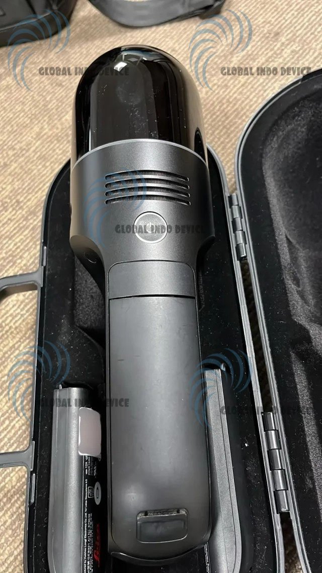
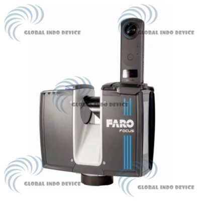
Dual Axis LiDar Dome
The smallest dual axis LiDAR available with best-in-class accuracy, enclosed in a fully protected and encapsulated dome that scans up to 420,000 points per second. Both axes constantly spin while scanning.
Multicamera Vision System
The BLK2GO’s vision system is a 12 megapixel detail camera for brilliant high-contrast imagery plus three panoramic cameras for visual navigation via SLAM, point cloud colorization, and capture of panoramic imagery.
The GRANDSLAM
The GRANDSLAM (Simultaneous Localization and Mapping) is a combination of high-speed dual axis LiDAR, multicamera vision system, and an inertial measurement unit that makes the BLK2GO self-navigating.
Specifications:
DESIGN & PHYSICAL
Housing : Black anodized aluminium
Dimensions : Height: 279 mm / Diameter: 80 mm
Weight : 650 g (775 g including battery)
Transport cover : BLK2GO transportation case
OPERATION
Stand-alone operation : One-button operation
Mobile device : BLK2GO Live app for iPhone (iOS 12.1 or later) including: live 2D and 3D visualization while scanning, device status and data management
Communication : Wireless (app connection)
Internal memory : 24 hours of scanning (compressed data) / 6 hours (uncompressed data)
Battery : Exchangeable, rechargeable Li-Ion battery (Leica GEB821) 45-50 minutes
LiDAR & IMAGING
Laser class : 1 (in accordance with IEC 60825-1)
Wavelength : 830 nm
Field of view : 360° (horizontal) / 270° (vertical)
Range : Min. 0.5 – up to 25 m
Point measurement rate : 420,000 pts/sec
SYSTEM PERFORMANCE (SLAM BASED)
Relative accuracy : 6-15 mm
Absolute position accuracy indoor : 20 mm
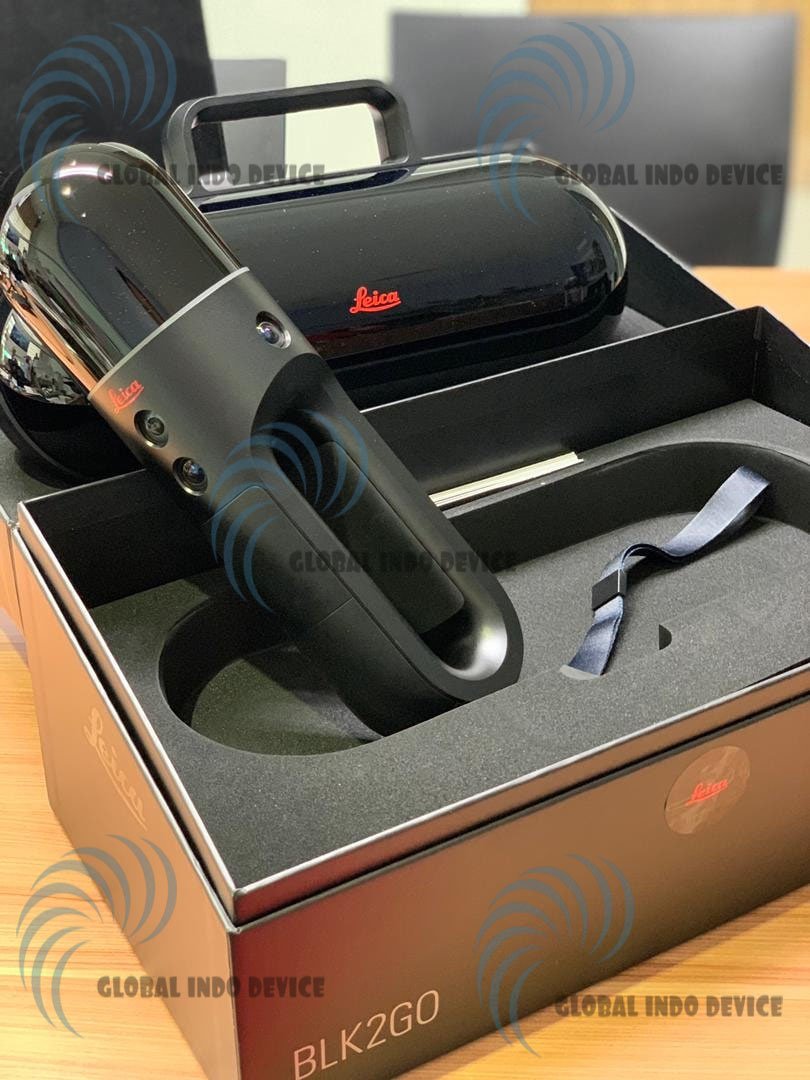
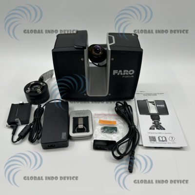
Package includes:
– 1x BLK2GO Scanner
– 1x BLK2GO Transportation Case
– 3x GEB821 Li-Ion Battery
– 1x GKL821 Multicharger incl. AC-Adapter
– 1x BLK2GO Table Stand
– 1x GEV278 USB C Cable
– 1x BLK2GO Wrist Strap
– 1x BLK2GO Maintenance Plug
– 1x Cover Eject Pin
– 1x BLK2GO Quick Guide
– 1x BLK2GO Live App Info Card
– 1x BLK2GO USB Documentaton Card
There are no reviews yet.