

Product details
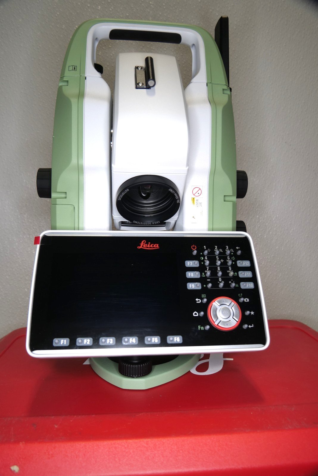
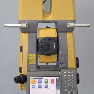
Leica TS20 Survey Total Station
Intelligent Robotic Total Station for High-Precision Surveying and Construction
The Leica TS20 Survey Total Station is a premium robotic surveying instrument engineered for high-accuracy geospatial measurement, construction layout, engineering surveying, and digital construction workflows. Combining advanced robotic automation, intelligent target recognition, superior EDM technology, and intuitive field software, the Leica TS20 delivers exceptional productivity and precision for demanding professional applications.
Designed for surveyors, engineers, infrastructure contractors, and geospatial professionals, the Leica TS20 supports one-person surveying, BIM integration, high-speed data acquisition, and advanced field automation to improve efficiency across complex surveying and construction projects.
Why Choose the Leica TS20 Survey Total Station?
The Leica TS20 is built to provide reliable robotic surveying performance with intelligent automation and survey-grade precision.
Key Advantages
Advanced Robotic Survey Technology
Supports fast and efficient one-person surveying workflows.
High-Precision Angle and Distance Measurement
Provides accurate coordinate positioning for professional projects.
Intelligent Target Recognition
Automatically identifies and tracks prism targets.
Long-Range EDM Performance
Delivers reliable prism and reflectorless measurements.
BIM and Digital Construction Integration
Supports modern digital engineering workflows.
Rugged Outdoor Durability
Engineered for demanding construction and survey environments.
High-Speed Field Productivity
Improves measurement speed and reduces operational downtime.
Applications of Leica TS20
The Leica TS20 Survey Total Station is suitable for a wide variety of professional geospatial and engineering applications.
Surveying Applications
Topographic Surveying
Captures accurate terrain and coordinate data.
Boundary and Land Surveying
Supports property mapping and legal measurement workflows.
Geodetic Control Surveys
Provides reliable control network measurements.
Infrastructure Surveying
Used for roads, bridges, tunnels, and rail projects.
Construction Applications
Construction Layout
Accurate positioning of structural and building components.
BIM Construction Workflows
Transfers digital models into field layout operations.
As-Built Verification
Confirms completed construction geometry accurately.
Structural Alignment
Supports steel, concrete, and industrial installation workflows.
Engineering Applications
Industrial Measurement
Supports equipment alignment and plant installation.
Utility Mapping
Captures infrastructure and utility positioning data.
Structural Monitoring
Measures displacement and structural movement.
Deformation Analysis
Supports engineering observation projects.
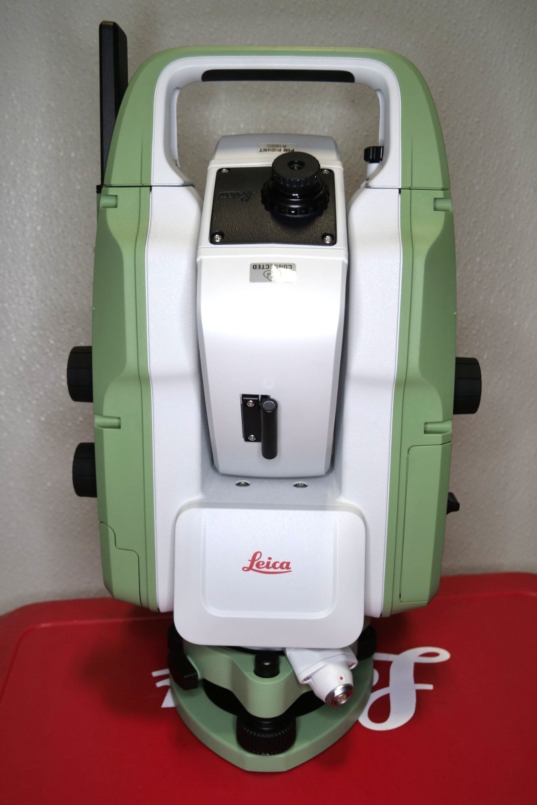
Leica TS20 Features
Advanced Robotic Surveying Technology
The Leica TS20 uses intelligent robotic automation to maximize productivity and field efficiency.
Automatic Prism Tracking
Continuously follows prism targets during operation.
One-Person Surveying
Reduces labor requirements and improves workflow efficiency.
Fast Servo Movement
Provides rapid robotic target acquisition and tracking.
Intelligent Prism Search
Automatically relocates lost targets quickly.
Leica ATRplus Technology
Automatic Target Recognition
Locks onto prism targets accurately and efficiently.
Stable Prism Tracking
Maintains reliable tracking even in difficult environments.
Improved Measurement Consistency
Enhances robotic survey precision.
High-Speed Tracking Performance
Supports fast-moving field workflows.
Advanced EDM Measurement System
Long-Range Prism Measurement
Provides accurate distance measurement across large sites.
Reflectorless Measurement Capability
Measures inaccessible surfaces safely and efficiently.
Fast Measurement Speed
Improves overall field productivity.
Survey-Grade Accuracy
Supports engineering and geospatial precision standards.
Leica Captivate Software
Intuitive Graphical Interface
Simplifies field measurement workflows.
3D Data Visualization
Improves project interpretation and layout accuracy.
Touchscreen Operation
Provides user-friendly survey management.
Digital Workflow Integration
Supports modern geospatial project environments.
DynamicLock Technology
Continuous Target Tracking
Maintains prism lock during movement.
Enhanced Robotic Stability
Improves tracking reliability in active environments.
Automatic Reacquisition
Quickly relocates prism targets after interruption.
Rugged Industrial Construction
Weather-Resistant Housing
Suitable for outdoor surveying conditions.
Heavy-Duty Durability
Designed for demanding construction environments.
Portable Professional Design
Easy transport and rapid field deployment.
Leica TS20 Measurement Functions
Robotic Surveying Functions
Prism-Based Measurement
Supports precise coordinate collection workflows.
Reflectorless Surveying
Measures objects without requiring prism access.
Remote-Controlled Operation
Supports wireless one-person field surveying.
Real-Time Coordinate Processing
Provides immediate measurement calculations.
Construction Layout Functions
Point Stakeout
Accurate positioning of construction elements.
Alignment Layout
Supports structural and infrastructure positioning.
Elevation Control
Maintains vertical construction precision.
BIM Data Integration
Supports model-driven construction workflows.
Monitoring and Engineering Functions
Structural Monitoring
Measures displacement and deformation accurately.
Industrial Alignment
Supports equipment installation and verification.
Infrastructure Observation
Monitors movement in bridges, tunnels, and structures.
Benefits of Using the Leica TS20
Increased Survey Productivity
Robotic automation accelerates field measurement operations.
Improved Accuracy
Provides reliable geospatial precision for professional applications.
Reduced Labor Costs
Supports efficient single-operator surveying workflows.
Better BIM Integration
Enhances digital construction and engineering processes.
Faster Construction Layout
Improves positioning efficiency on project sites.
Reduced Human Error
Automated tracking improves measurement consistency.
Leica TS20 Technical Specifications
General Specifications
Product Type
Robotic Survey Total Station
Intended Applications
Surveying, Construction, and Engineering Measurement
Measurement Technology
Electronic Angle and Distance Measurement
Operating Modes
- Robotic Surveying
- Reflectorless Measurement
- Construction Stakeout
- Structural Monitoring
- Prism Tracking
Workflow Integration
Leica Geosystems and BIM Compatible
Angle Measurement Specifications
Horizontal Angle Measurement
High-Precision Digital Encoder System
Vertical Angle Measurement
Survey-Grade Elevation Measurement
Angular Accuracy
Professional Geospatial Precision Capability
Resolution
Advanced High-Resolution Encoder Technology
Distance Measurement Specifications
EDM Technology
Advanced Electronic Distance Measurement
Prism Measurement
Long-Range High-Accuracy Distance Capability
Reflectorless Measurement
Non-Prism Distance Measurement Functionality
Measurement Speed
Rapid Field Data Acquisition Performance
Coordinate Precision
Engineering and Survey Accuracy Standards
Robotic Specifications
Tracking Technology
Automatic Prism Tracking System
Target Recognition
Leica ATRplus Intelligent Tracking
Dynamic Tracking
DynamicLock Continuous Target Following
Target Search Function
Automatic Prism Recovery Capability
Remote Survey Operation
Wireless One-Person Workflow Support
Software and Display Specifications
User Interface
Leica Captivate Touchscreen Interface
Workflow Visualization
3D Data Display and Project Management
Data Storage
Integrated Project Data Management
BIM Compatibility
Supports Digital Construction Integration
Software Integration
Compatible with Leica Geosystems Software Solutions
Mechanical Specifications
Instrument Housing
Industrial Weather-Resistant Construction
Mounting Platform
Tripod-Compatible Survey Base
Portability
Compact Professional Survey Design
Durability
Heavy-Duty Outdoor Engineering Construction
Communication Specifications
Wireless Connectivity
Supports Remote Instrument Communication
Data Transfer
Integrated Digital File Exchange Capability
Remote Operation
Wireless Robotic Instrument Control
Power Specifications
Power Source
Rechargeable Lithium-Ion Battery System
Operating Time
Extended Portable Field Operation
Charging System
External Smart Charging Adapter
Portable Capability
Cordless Survey Workflow Support
Environmental Specifications
Operating Environment
Outdoor Surveying and Construction Applications
Weather Protection
Dust and Moisture Resistant Design
Field Durability
Designed for Harsh Industrial Conditions
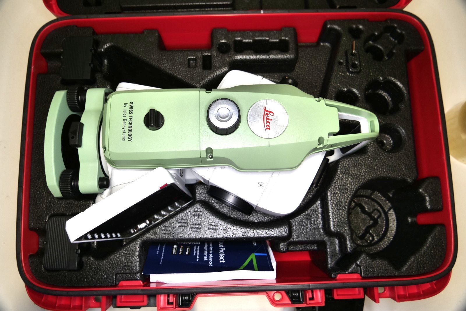
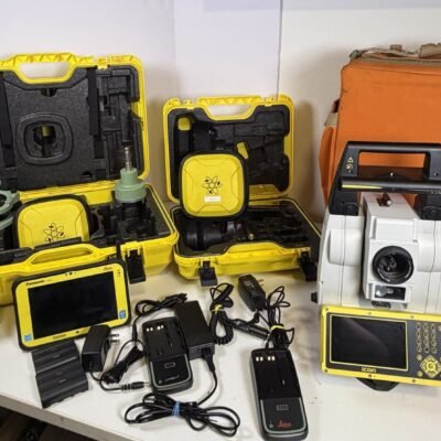
Leica TS20 Package
Included Components
Leica TS20 Instrument
Robotic total station unit.
Rechargeable Batteries
Portable power system and charger.
Survey Prism Accessories
Target prisms and field measurement components.
Communication Equipment
Wireless connectivity and remote operation accessories.
Carrying Case
Protective transport and storage solution.
Calibration Accessories
Instrument setup and adjustment tools.
User Documentation
Operational manuals and software guides.
Industries Using Leica TS20
Land Surveying
Supports geospatial mapping and coordinate measurement.
Construction Industry
Provides layout, positioning, and verification workflows.
Civil Engineering
Supports infrastructure and engineering projects.
Transportation Infrastructure
Used for roads, bridges, tunnels, and rail systems.
Industrial Engineering
Provides accurate equipment alignment and installation.
Structural Monitoring
Measures movement and deformation in critical structures.
Leica TS20 vs Conventional Total Stations
Advantages of Robotic Total Stations
Automated Prism Tracking
Improves survey productivity significantly.
Faster Data Collection
Accelerates measurement workflows.
One-Person Operation
Reduces field crew requirements.
Better Digital Workflow Integration
Supports BIM and digital construction environments.
Improved Measurement Reliability
Enhances accuracy and consistency.
There are no reviews yet.