

Product details
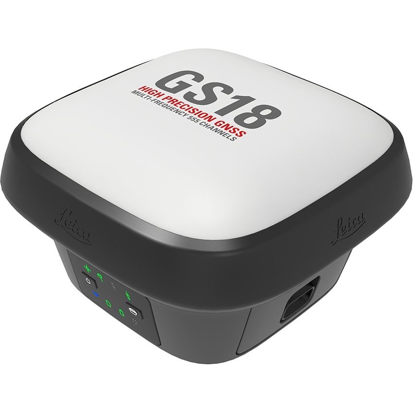
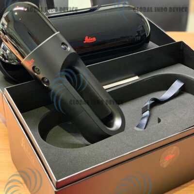
Leica GS18 T Smart GNSS
The Leica GS18 T Smart GNSS is an innovative smart GNSS receiver designed to deliver fast, accurate, and reliable positioning for surveying, mapping, and construction applications. Developed by Leica Geosystems, the GS18 T combines advanced RTK positioning, IMU-based tilt compensation, multi-constellation satellite tracking, and rugged field durability into a compact professional solution.
Built for modern digital surveying workflows, the Leica GS18 T allows surveyors and construction professionals to capture accurate points without leveling the survey pole, significantly improving productivity and efficiency in challenging environments.
Why Choose Leica GS18 T Smart GNSS
Revolutionary Tilt Compensation Technology
The Leica GS18 T eliminates the need to keep the survey pole perfectly vertical by using advanced inertial measurement technology.
Benefits
- Faster field measurements
- Easier point collection near obstacles
- Increased operator safety
- Reduced physical fatigue
- Improved productivity on difficult terrain
High-Precision RTK GNSS Performance
The GS18 T delivers survey-grade RTK positioning accuracy for high-demand geospatial applications.
RTK Advantages
- Real-time centimeter-level positioning
- Reliable correction handling
- Fast signal initialization
- Stable positioning performance
Multi-Constellation GNSS Tracking
The receiver supports multiple global navigation satellite systems to maximize signal availability and positioning reliability.
Supported Satellite Constellations
- GPS
- GLONASS
- Galileo
- BeiDou
- QZSS
- SBAS
Key Features of Leica GS18 T Smart GNSS
Integrated Smart Antenna Design
The Leica GS18 T combines antenna technology, GNSS processing, wireless communication, and tilt compensation into a compact smart receiver.
Smart Design Advantages
- Lightweight operation
- Simplified field setup
- Reduced cable complexity
- Enhanced portability
IMU-Based Tilt Compensation
The integrated IMU enables accurate measurements without requiring magnetic calibration.
Key Tilt Features
- Calibration-free operation
- Immune to magnetic disturbances
- Accurate tilted pole measurements
- Stable motion compensation
High-Speed RTK Engine
The RTK engine ensures fast ambiguity resolution and stable correction performance.
Performance Benefits
- Rapid initialization
- Reliable signal recovery
- Long baseline support
- Consistent measurement accuracy
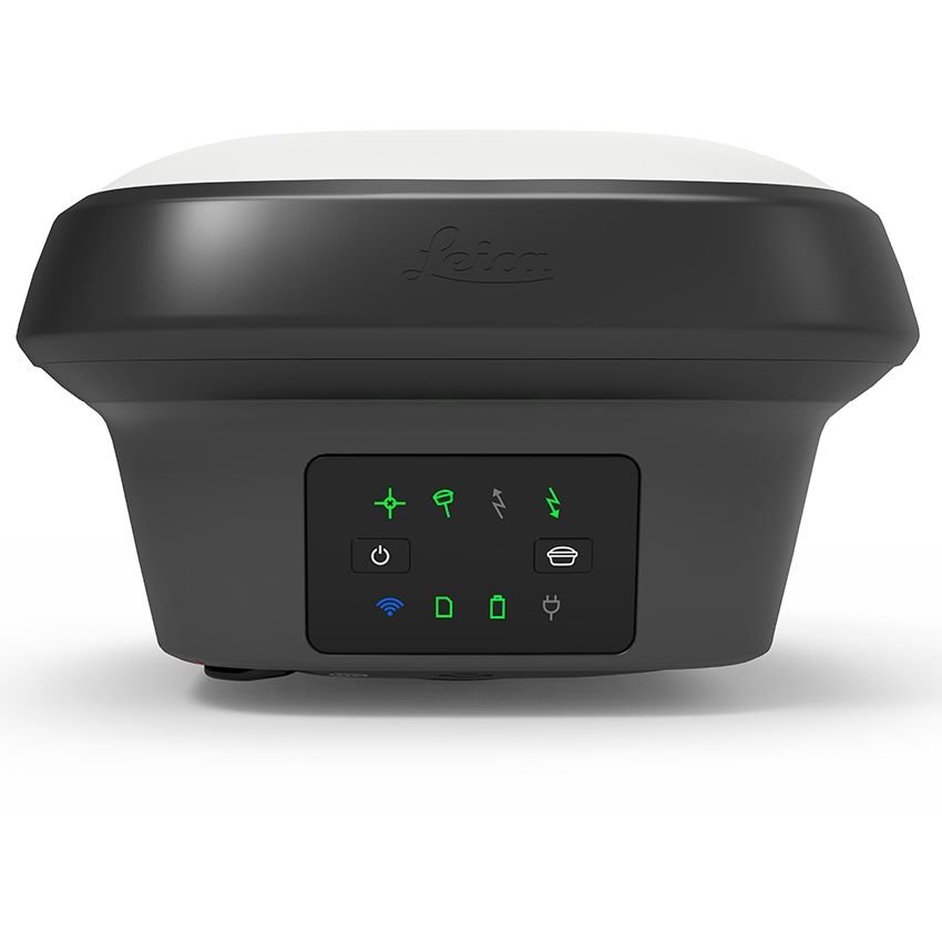
Advanced Field Connectivity
The system supports multiple communication methods for seamless field integration.
Connectivity Options
- Bluetooth
- Wi-Fi
- Cellular modem
- USB communication
- NTRIP support
Leica GS18 T Smart GNSS Specifications
General Specifications
| Specification | Details |
|---|---|
| Product Name | Leica GS18 T Smart GNSS |
| Product Type | Smart GNSS RTK Rover |
| Manufacturer | Leica Geosystems |
| Positioning Technology | Multi-Frequency GNSS |
| GNSS Type | Survey-Grade RTK Receiver |
| Primary Applications | Surveying, Construction, Mapping |
| Operating Modes | Rover / Base |
| Positioning Methods | RTK, Static, DGPS, Network RTK |
| Tilt Compensation | IMU-Based |
| Workflow Integration | Leica Captivate Ecosystem |
GNSS Tracking Specifications
Satellite Tracking Performance
| Specification | Details |
|---|---|
| GPS Tracking | Supported |
| GLONASS Tracking | Supported |
| Galileo Tracking | Supported |
| BeiDou Tracking | Supported |
| QZSS Support | Supported |
| SBAS Support | Supported |
| Multi-Frequency Tracking | Supported |
| Multi-Constellation Tracking | Supported |
| Satellite Channels | Advanced High-Capacity Engine |
| Signal Acquisition | Fast |
| Signal Stability | High |
| RTK Correction Capability | Supported |
| PPP Support | Supported |
| Dynamic Tracking | Supported |
| Signal Reacquisition | Rapid Recovery |
Positioning Accuracy Specifications
RTK & Static Accuracy
| Specification | Details |
|---|---|
| RTK Horizontal Accuracy | Centimeter-Level |
| RTK Vertical Accuracy | High Precision Elevation |
| Static Survey Accuracy | Survey Grade |
| Initialization Time | Rapid |
| Long Baseline RTK | Supported |
| Repeatability | Excellent |
| Dynamic Positioning | Stable |
| Network RTK Compatibility | Supported |
| Measurement Consistency | High |
| Stakeout Accuracy | Optimized |
Tilt Compensation Specifications
IMU & Tilt Technology
| Specification | Details |
|---|---|
| Tilt Compensation Technology | IMU-Based |
| Magnetic Calibration Requirement | None |
| Magnetic Interference Immunity | Supported |
| Pole Tilt Measurement | Supported |
| Automatic Motion Compensation | Supported |
| Dynamic Tilt Stability | High Precision |
| Level-Free Surveying | Supported |
| Sensor Integration | Advanced Inertial System |
| Calibration-Free Workflow | Supported |
Communication Specifications
Connectivity & Data Transfer
| Specification | Details |
|---|---|
| Bluetooth Connectivity | Supported |
| Wi-Fi Connectivity | Supported |
| Cellular Communication | Supported |
| USB Interface | Supported |
| Serial Communication | Supported |
| NTRIP Compatibility | Supported |
| Real-Time Data Streaming | Supported |
| Remote Configuration | Supported |
| Cloud Synchronization | Supported |
| Wireless RTK Correction Reception | Supported |
Physical Specifications
Hardware Design & Durability
| Specification | Details |
|---|---|
| Housing Design | Rugged Industrial Housing |
| Weight | Lightweight Portable Design |
| Pole Mount Compatibility | Supported |
| Tripod Compatibility | Supported |
| Water Resistance | Industrial Grade |
| Dust Resistance | Supported |
| Shock Resistance | Supported |
| Vibration Resistance | Supported |
| Compact Form Factor | Optimized |
| Outdoor Operation | Full-Day Field Use |
Power Specifications
Battery & Power Management
| Specification | Details |
|---|---|
| Battery Type | Rechargeable Lithium-Ion |
| Battery Runtime | Full-Day Operation |
| Hot-Swap Battery Support | Supported |
| External Power Input | Supported |
| Intelligent Power Management | Supported |
| Charging Interface | Industrial Charging System |
| Power Consumption | Optimized |
Environmental Specifications
Field Operation Performance
| Specification | Details |
|---|---|
| Operating Environment | Survey & Construction Sites |
| Extreme Temperature Support | Supported |
| Rain Operation | Supported |
| Humidity Resistance | Supported |
| Dusty Environment Operation | Supported |
| UV Resistance | Supported |
| Harsh Outdoor Conditions | Optimized |
| Industrial Site Compatibility | Supported |
Data Management Specifications
Survey Data Handling
| Specification | Details |
|---|---|
| Real-Time Data Collection | Supported |
| Coordinate System Compatibility | Multiple Coordinate Systems |
| Data Export Formats | Industry Standard Formats |
| Cloud Collaboration | Supported |
| Survey Data Logging | Supported |
| GIS Integration | Supported |
| CAD Workflow Support | Supported |
| BIM Workflow Compatibility | Supported |
Software Compatibility
Leica Ecosystem Integration
| Software Platform | Compatibility |
|---|---|
| Leica Captivate | Supported |
| Leica Infinity | Supported |
| Leica Geo Office | Supported |
| CAD Platforms | Supported |
| BIM Platforms | Supported |
| GIS Software | Supported |
| Cloud Collaboration Systems | Supported |
| Construction Workflow Platforms | Supported |
Applications of Leica GS18 T Smart GNSS
Land Surveying
The GS18 T is ideal for professional surveying applications requiring fast and accurate positioning.
Survey Tasks
- Topographic surveys
- Boundary surveys
- Control point establishment
- Elevation measurements
Construction Layout
The system supports precise construction stakeout and site positioning workflows.
Construction Applications
- Building layout
- Utility positioning
- Structural alignment
- Foundation stakeout
Infrastructure Development
The Leica GS18 T is widely used in infrastructure projects including transportation, utilities, and civil engineering.
GIS & Mapping
The receiver enables efficient GIS data collection and geospatial mapping workflows.
GIS Applications
- Asset mapping
- Utility surveys
- Environmental monitoring
- Spatial data collection
Advantages of Leica GS18 T Smart GNSS
Increased Productivity
Tilt compensation technology significantly reduces measurement time in the field.
Improved Accuracy
Advanced GNSS tracking ensures highly reliable survey-grade positioning.
Simplified Workflows
Calibration-free tilt operation reduces setup complexity.
Reliable Performance
Multi-constellation GNSS improves signal availability in difficult environments.
Rugged Durability
Industrial-grade design ensures long-term field reliability.
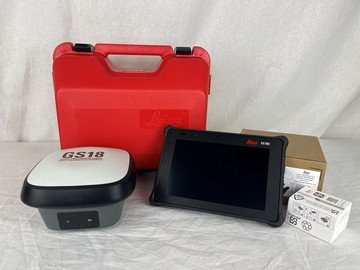
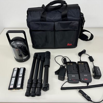
Standard Package Contents
Included Components
- Leica GS18 T Smart GNSS Receiver
- Rechargeable Batteries
- Battery Charger
- Communication Accessories
- Carrying Case
- Pole Mount Hardware
- USB Data Cable
- User Documentation
Optional Accessories
Expansion & Field Accessories
- Field Controllers
- Survey Poles
- External Radio Modules
- Additional Batteries
- RTK Network Services
- Tripod Systems
- Cloud Collaboration Packages
- Protective Field Cases
Industries Using Leica GS18 T
| Industry | Application |
|---|---|
| Surveying | High-Precision Surveys |
| Construction | Site Layout |
| Civil Engineering | Infrastructure Development |
| Utilities | Asset Mapping |
| Transportation | Road & Rail Projects |
| Mining | Site Positioning |
| Environmental | GIS Mapping |
| Energy | Facility Surveys |
There are no reviews yet.