
Product details
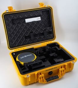
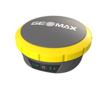
GeoMax Zenith60 Pro Survey Receiver
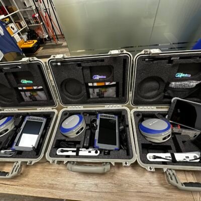
The GeoMax Zenith60 Pro Survey Receiver is a professional-grade GNSS smart antenna engineered for surveyors, construction professionals, GIS specialists, and geospatial engineers who demand reliable positioning performance in every environment. Built for fast initialization, robust satellite tracking, and highly accurate RTK measurements, the Zenith60 Pro delivers dependable results even under dense canopy, urban obstructions, and challenging jobsite conditions.
Designed as part of the GeoMax ecosystem, the Zenith60 Pro integrates seamlessly with X-PAD field software, total stations, cloud platforms, and office processing solutions to create a fully connected surveying workflow.
Why Choose the GeoMax Zenith60 Pro?
The Zenith60 Pro combines powerful multi-frequency GNSS technology with intelligent tilt compensation, rugged field durability, and flexible communication options. It is optimized for professionals who require:
- High-precision RTK surveying
- Reliable measurements in difficult environments
- Fast setup and initialization
- Calibration-free tilt compensation
- Seamless field-to-office integration
- Long operational battery life
- Multi-constellation satellite tracking
- Lightweight and portable field equipment
Its advanced positioning engine supports over 800 GNSS channels, enabling faster satellite acquisition and stronger signal stability for modern surveying applications.
Key Features of GeoMax Zenith60 Pro
High-Performance Multi-Constellation GNSS Engine
The Zenith60 Pro supports full GNSS constellation tracking for superior satellite availability and improved positioning reliability.
Supported Satellite Systems
- GPS
- GLONASS
- Galileo
- BeiDou
- QZSS
- NavIC
- SBAS
Supported Frequencies
GPS
- L1 C/A
- L1P
- L1C
- L2C
- L2P
- L5
GLONASS
- L1 C/A
- L1P
- L2 C/A
- L2P
- L3
Galileo
- E1
- E5a
- E5b
- E6
- AltBOC
BeiDou
- B1I
- B1C
- B2I
- B2a
- B2b
- B3I
- ACEBOC
QZSS
- L1 C/A
- L1C
- L2C
- L5
- L6
NavIC
- L5
SBAS
- EGNOS
- WAAS
- MSAS
- GAGAN
The receiver’s multi-frequency tracking capability improves RTK reliability and minimizes signal interruptions in obstructed environments.
Calibration-Free Tilt Compensation
The integrated IMU-based tilt compensation technology enables surveyors to measure points without leveling the pole precisely.
Benefits of Tilt Compensation
- Faster point collection
- Improved field productivity
- Safer measurements in hazardous areas
- Access to difficult or obstructed points
- Reduced operator fatigue
The Zenith60 Pro provides magnetic-interference-resistant tilt measurements for enhanced reliability in urban and industrial environments.
Reliable Performance Under Canopy and Urban Conditions
The receiver is specifically designed to maintain stable RTK performance in:
- Dense vegetation
- Forested survey areas
- Urban canyons
- Construction sites
- Infrastructure corridors
- Industrial environments
Its advanced signal processing and powerful GNSS engine allow consistent positioning performance where weaker receivers may struggle.
GeoMax Zenith60 Pro Technical Specifications
GNSS Receiver Specifications
| Feature | Specification |
|---|---|
| GNSS Channels | 800+ Channels |
| Position Update Rate | Up to 20 Hz |
| Initialization Time | Typically 4 Seconds |
| GNSS Technology | Multi-Frequency, Multi-Constellation |
| Tilt Compensation | IMU-Based |
| RTK Capability | Yes |
| Network RTK | Yes |
| Static Surveying | Yes |
| PPP Support | TerraStar-C Pro Compatible |
Accuracy Specifications
RTK Accuracy
| Mode | Horizontal Accuracy | Vertical Accuracy |
|---|---|---|
| RTK | 8 mm + 1 ppm RMS | 15 mm + 1 ppm RMS |
| Network RTK | 8 mm + 0.5 ppm RMS | 15 mm + 0.5 ppm RMS |
Static Accuracy
| Mode | Horizontal Accuracy | Vertical Accuracy |
|---|---|---|
| Static | 3 mm + 0.5 ppm RMS | 5 mm + 0.5 ppm RMS |
| Long Static | 3 mm + 0.1 ppm RMS | 3.5 mm + 0.4 ppm RMS |
Tilted RTK Measurement
| Measurement | Specification |
|---|---|
| Additional Horizontal Error | 2 cm at 30° Tilt |
Communication and Connectivity
The Zenith60 Pro offers comprehensive connectivity for modern field workflows.
Integrated Communication Options
- 4G LTE Cellular Modem
- Bluetooth 2.1 + EDR
- Bluetooth 5.0
- Wi-Fi 802.11 b/g/n
- USB Port
- Serial Port
- TCP/IP Communication
- UHF Radio (Optional)
- SIM Card Support
Supported Protocols
- RTCM 2.1
- RTCM 2.3
- RTCM 3.0
- RTCM 3.1
- RTCM 3.2
- RTCM 3.3
- RTCM 3.4
- CMR
- CMR+
NMEA Output
- NMEA v3.1
- NMEA v4.1
Data Storage and Logging
| Feature | Specification |
|---|---|
| Internal Storage | 8 GB |
| External Storage | microSD Card |
| Data Logging | Raw GNSS & RINEX |
| File Transfer | USB / Wi-Fi |
The receiver supports reliable static data logging and easy transfer of survey datasets for post-processing applications.
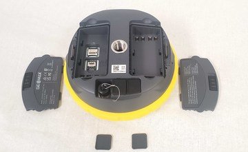
Battery and Power System
| Feature | Specification |
|---|---|
| Battery Type | Dual Hot-Swappable Li-Ion |
| Battery Capacity | 3.4 Ah / 7.2 V |
| Static Operation Time | Up to 12.5 Hours |
| Rover Operation Time | Up to 11 Hours |
| External Power | 9V to 28V |
The hot-swappable battery system allows uninterrupted field operation during extended survey sessions.
Physical Specifications
| Feature | Specification |
|---|---|
| Height | 75 mm |
| Diameter | 166.8 mm |
| Weight | 1.14 kg Without Batteries |
| Environmental Protection | IP68 |
| Dust Protection | Fully Dustproof |
| Water Resistance | Waterproof |
| Operating Temperature | -40°C to +65°C |
| Military Standard | MIL-STD-810G |
The rugged housing ensures reliable operation in harsh environmental conditions including rain, dust, heat, and freezing temperatures.
GeoMax X-PAD Software Integration
Connected Digital Survey Workflow
The Zenith60 Pro integrates directly with the GeoMax X-PAD software ecosystem.
Compatible Solutions
- X-PAD Ultimate
- X-PAD Office Fusion
- X-PAD 365 Cloud Platform
- GeoMax Total Stations
- GeoMax Laser Scanners
- Drone Data Processing Workflows
Workflow Advantages
- Simplified field data collection
- Real-time cloud synchronization
- Fast office processing
- Unified project management
- Efficient collaboration between field and office teams
Applications of GeoMax Zenith60 Pro
Land Surveying
The Zenith60 Pro is ideal for:
- Boundary surveys
- Topographic surveys
- Cadastral mapping
- Control point establishment
- Geodetic surveys
Construction Surveying
Perfect for:
- Site layout
- Grade checking
- As-built surveys
- Machine control support
- Infrastructure construction
GIS and Mapping
Suitable for:
- GIS data collection
- Utility mapping
- Asset management
- Environmental surveys
- Drone ground control points
Engineering and Infrastructure
Used extensively for:
- Road construction
- Railway surveying
- Tunnel projects
- Bridge monitoring
- Mining operations
Advantages of GeoMax Zenith60 Pro
Fast Initialization and Stable RTK
The advanced GNSS engine provides rapid RTK fixing with stable performance even in difficult satellite conditions.
Lightweight and Portable
At just over 1 kilogram, the receiver is easy to transport and operate during long survey days.
Rugged Field Design
The IP68-rated housing and military-grade durability ensure reliable operation in extreme environments.
Seamless Connectivity
Integrated LTE, Bluetooth, Wi-Fi, and optional UHF radio provide flexible communication options for every survey workflow.
Efficient Tilt Surveying
IMU-based tilt compensation significantly improves field productivity and reduces setup time.
There are no reviews yet.