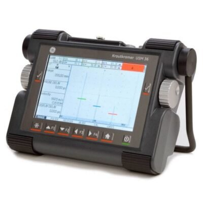
Krautkramer USM 36 Ultrasonic Tester
Krautkramer USM 36 Ultrasonic Tester is a rugged portable ultrasonic flaw detector featuring advanced weld inspection, thickness measurement, DAC/AVG analysis, and reliable non-destructive testing performance for industrial applications.
Krautkramer USM 36 Ultrasonic Tester is a rugged portable ultrasonic flaw detector featuring advanced weld inspection, thickness measurement, DAC/AVG analysis, and reliable non-destructive testing performance for industrial applications.
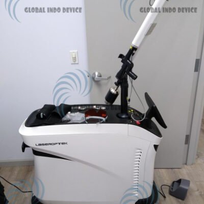
LaserOptek PicoLO Picosecond 2019
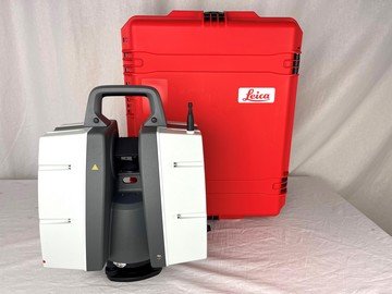
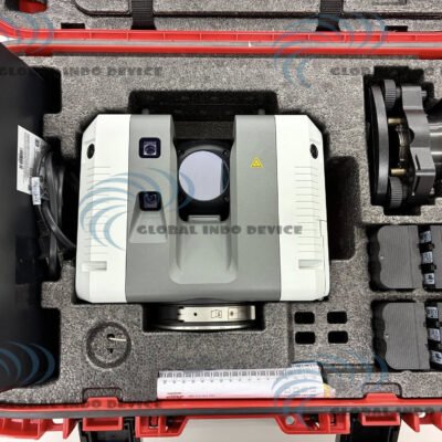
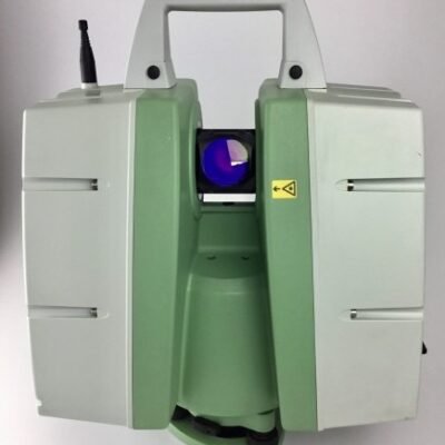
Leica 3D ScanStation P40 Laser Scanner
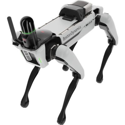
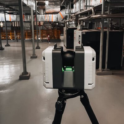
Leica BLK ARC Autonomous Scanner
The Leica BLK ARC Autonomous Scanner is a cutting-edge autonomous reality capture solution that transforms robotic platforms into intelligent 3D mapping systems. Built for industrial automation, it combines LiDAR scanning, SLAM navigation, and edge computing to deliver real-time, high-accuracy spatial data without manual operation. Ideal for construction, mining, infrastructure inspection, and autonomous robotics applications.
The Leica BLK ARC Autonomous Scanner is a cutting-edge autonomous reality capture solution that transforms robotic platforms into intelligent 3D mapping systems. Built for industrial automation, it combines LiDAR scanning, SLAM navigation, and edge computing to deliver real-time, high-accuracy spatial data without manual operation. Ideal for construction, mining, infrastructure inspection, and autonomous robotics applications.
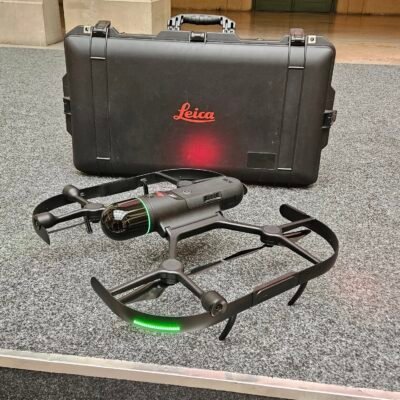
Leica BLK2FLY Drone LiDAR Scanner
Leica BLK2GO Handheld Imaging Laser Scanner
Leica BLK360 3D Scanner Imaging System
The Leica BLK360 is a compact 3D laser scanner that combines LiDAR technology and integrated imaging to deliver fast, accurate, and efficient reality capture for professional workflows.
The Leica BLK360 is a compact 3D laser scanner that combines LiDAR technology and integrated imaging to deliver fast, accurate, and efficient reality capture for professional workflows.
Leica BLK360 G1 Imaging Scanner
The Leica BLK360 G1 Imaging Scanner is a lightweight and portable 3D reality capture solution that combines LiDAR scanning, panoramic HDR imaging, and thermal imaging into one compact device. Designed for architecture, construction, surveying, and facility management, it enables fast and accurate point cloud generation for digital documentation and BIM applications.
The Leica BLK360 G1 Imaging Scanner is a lightweight and portable 3D reality capture solution that combines LiDAR scanning, panoramic HDR imaging, and thermal imaging into one compact device. Designed for architecture, construction, surveying, and facility management, it enables fast and accurate point cloud generation for digital documentation and BIM applications.
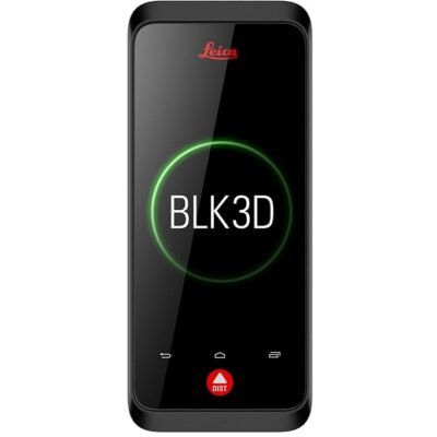
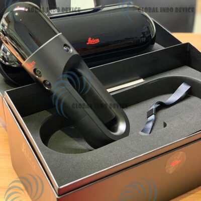
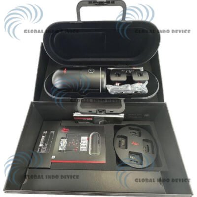
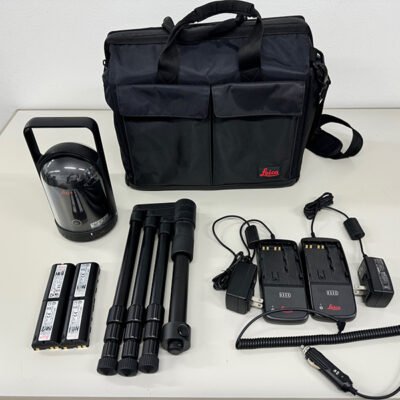
Leica BLK3D Real-Time Imager
The Leica BLK3D Real-Time Imager is an advanced handheld imaging solution that captures measurable photographs in real time using stereo photogrammetry technology. Designed for architecture, construction, engineering, surveying, and facility management, it enables users to extract accurate dimensions and spatial measurements directly from images for efficient digital documentation workflows.
The Leica BLK3D Real-Time Imager is an advanced handheld imaging solution that captures measurable photographs in real time using stereo photogrammetry technology. Designed for architecture, construction, engineering, surveying, and facility management, it enables users to extract accurate dimensions and spatial measurements directly from images for efficient digital documentation workflows.
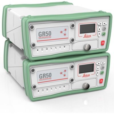
Leica GR30 GR50 Reference Receiver
The Leica GR30 GR50 Reference Receiver is a high-performance GNSS reference station solution designed for continuous monitoring, geodetic infrastructure, CORS networks, and scientific research. Featuring multi-constellation GNSS tracking, secure data handling, real-time streaming, and long-term operational stability, it provides reliable geodetic-grade positioning for permanent monitoring applications.
The Leica GR30 GR50 Reference Receiver is a high-performance GNSS reference station solution designed for continuous monitoring, geodetic infrastructure, CORS networks, and scientific research. Featuring multi-constellation GNSS tracking, secure data handling, real-time streaming, and long-term operational stability, it provides reliable geodetic-grade positioning for permanent monitoring applications.
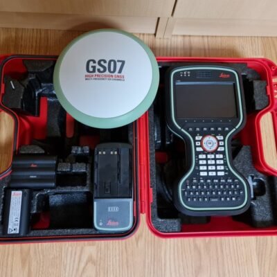
Leica GS07 CS20 Survey System
Leica GS15 GNSS Receiver
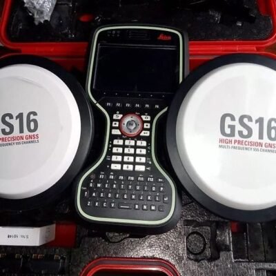
Leica GS16 RTK GNSS Receiver
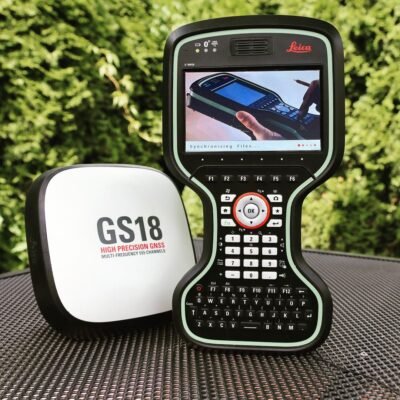
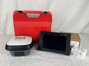
Leica GS18 I GNSS Rover
Leica GS18 T Smart GNSS
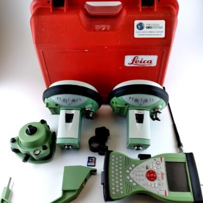
Leica iCG60 Base Rover Kit
The Leica iCG60 Base Rover Kit is a flexible GNSS system offering base and rover functionality with high-accuracy positioning for construction sites.
The Leica iCG60 Base Rover Kit is a flexible GNSS system offering base and rover functionality with high-accuracy positioning for construction sites.
Leica iCON GPS 30 RTK Rover
Leica iCON GPS 70 RTK Rover
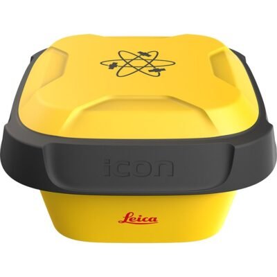
Leica iCON GPS 80 GNSS Receiver
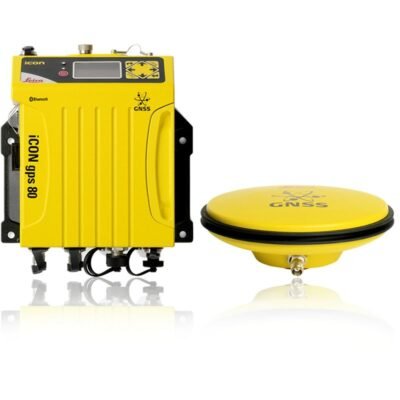
Leica iCON GPS 80 GNSS System
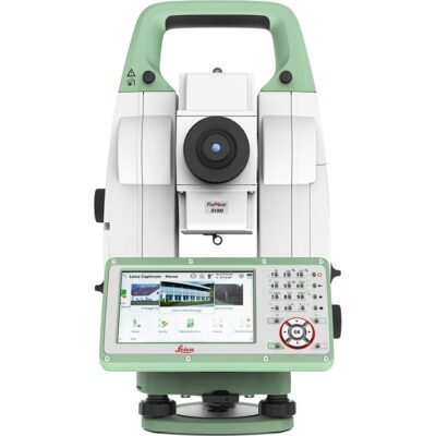
Leica iCON iCB70 – 1’’ R1000
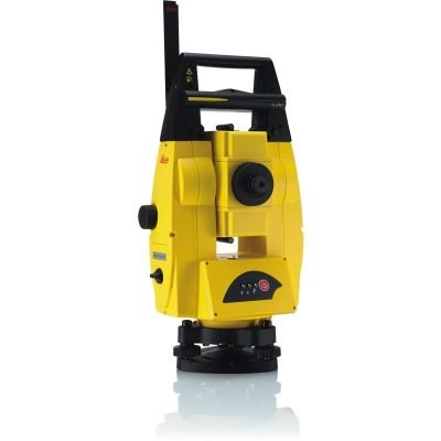
Leica iCON Robot 50 Robotic Total Station
A robotic total station designed for construction layout, offering high accuracy, automated tracking, and user-friendly software integration.
A robotic total station designed for construction layout, offering high accuracy, automated tracking, and user-friendly software integration.
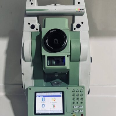
Leica iCR70 R500 Smart Robotic Total Station
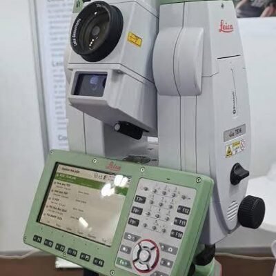
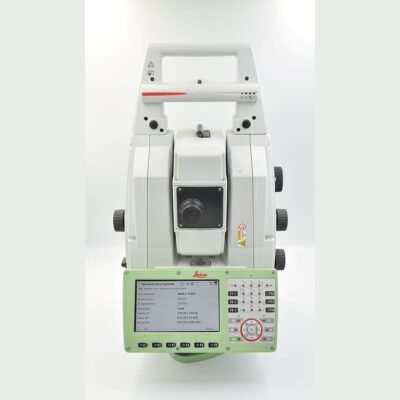
Leica iCR80 2” Total Station
The Leica iCR80 2” Total Station is a professional robotic total station designed for construction layout, engineering surveys, and infrastructure positioning. Featuring 2 arc-second accuracy, intelligent prism tracking, reflectorless EDM technology, and wireless communication, it provides accurate and efficient field performance for demanding surveying applications.
The Leica iCR80 2” Total Station is a professional robotic total station designed for construction layout, engineering surveys, and infrastructure positioning. Featuring 2 arc-second accuracy, intelligent prism tracking, reflectorless EDM technology, and wireless communication, it provides accurate and efficient field performance for demanding surveying applications.
Leica iCT30 Automatic Total Station
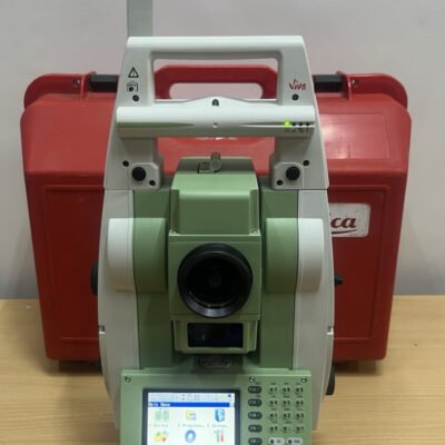
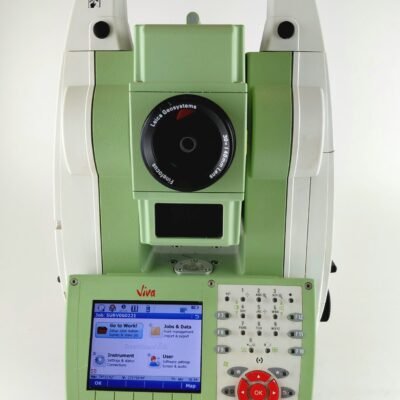
Leica Nova MS50 Surveying System
The Leica Nova MS50 is a high-performance MultiStation that integrates total station accuracy with 3D laser scanning for efficient and precise data capture.
The Leica Nova MS50 is a high-performance MultiStation that integrates total station accuracy with 3D laser scanning for efficient and precise data capture.
Leica Nova MS60 MultiStation Robotic Total Station
Leica RTC360 3D Laser Scanner
The Leica RTC360 is a high-speed 3D laser scanner designed for efficient and precise reality capture. Featuring advanced VIS technology and integrated imaging, it enables fast data collection, automatic scan alignment, and high-quality point cloud generation for professional applications.
The Leica RTC360 is a high-speed 3D laser scanner designed for efficient and precise reality capture. Featuring advanced VIS technology and integrated imaging, it enables fast data collection, automatic scan alignment, and high-quality point cloud generation for professional applications.
Leica RTC360 3D Scanner
Leica ScanStation C10 Laser Scanning System
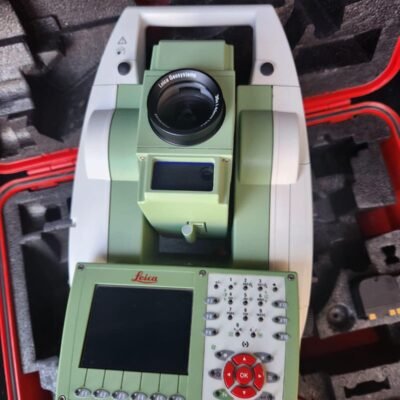
Leica TCRP1205+ R1000 Survey Station
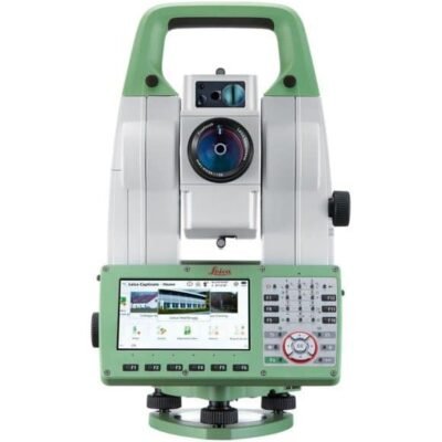
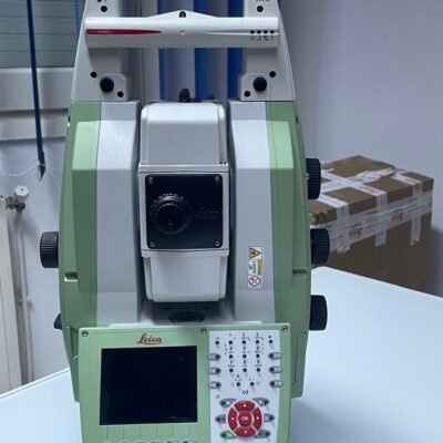
Leica TM60 0.5” Total Station
The Leica TM60 0.5” Total Station is a high-precision robotic monitoring total station designed for structural monitoring, deformation analysis, and advanced engineering surveys. Featuring 0.5 arc-second accuracy, ATRplus target recognition, robotic automation, and long-range EDM technology, it provides reliable performance for critical infrastructure and geospatial monitoring applications.
The Leica TM60 0.5” Total Station is a high-precision robotic monitoring total station designed for structural monitoring, deformation analysis, and advanced engineering surveys. Featuring 0.5 arc-second accuracy, ATRplus target recognition, robotic automation, and long-range EDM technology, it provides reliable performance for critical infrastructure and geospatial monitoring applications.
Leica TS10 Manual Total Station
Leica TS11 3" R500 Survey Total Station
Leica TS12 R400 Total Station
Leica TS13 - Mid-Range Total Station
Leica TS15 R1000 3" Robotic Total Station
A high-accuracy robotic total station with 3" angular precision and up to 1000 m reflectorless measurement, ideal for professional surveying applications.
A high-accuracy robotic total station with 3" angular precision and up to 1000 m reflectorless measurement, ideal for professional surveying applications.